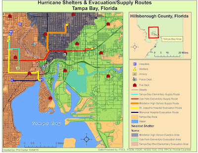
This was the second week of my Network Analyst project. After preparing the data last week, I
calculated two evacuation routes from a hospital in the flood zone to hospitals
that were close by and at a higher elevation.
Then I calculated supply routes from the National Guard Armory to the three
designated Storm Shelters. Both the
evacuation routes and supply routes were then assigned a name and separate
color. This was all completed the “Routes”
tool in the Network analyst toolbox in ArcGIS.
Next, using the “New Service Area” function also located in the Network
Analyst toolbox, I calculated the nearest Designated Storm Shelter for areas
within Tampa Bay. Once the polygons were
created they were each also given a different color. Once the routes and storm shelter areas were
calculated I created the map above and like last week shared it as a map
package. Then I wrote an addendum to my E-mail explaining what I have done to
date. The map package, and e-mail were
then zipped into a single file and put into the dropbox.

No comments:
Post a Comment