Showing posts with label GIS 4102 Programming. Show all posts

Saturday, August 3, 2013

GISProgramming Module 11

This is a screen shot of my Module 11 assignment for my GIS Programming course.  We were provided a script to which we had to make a few modifications. Once that was complete, the script was embedded in the script tool for ease of sharing and so it could be password protected. On the left of the screen shot is the tool dialog box and to the right is the result of the tool being ran.  This was the last module for this course. I have enjoyed this course because it was challenging and rewarding.

Thursday, August 1, 2013

Module 10 Creating Custom Tools


The above screen shots are a result of Module 10 of my GIS Programming Course. The  first screen shot is of the script tool window. This is what is generated after setting the parameters for the tool, this lets the user choose things like input files, output file location and other tool parameters.
The second screen shot is the result of the tool being successfully ran after the parameters were set in the script.

Thursday, July 25, 2013

GIS Programming - Participation Assignment II

GIS as a Tool in Participatory Natural Resource Management

As the title states this article is about participatory GIS being used a tool in the management of natural resources.  Although the article is ten years old, as a natural resource manager, I still found it interesting and relevant.  The article covers a study of three areas in Peru where local farmers, Non-governmental organizations (NGOs), and GIS professional worked together to analyze data, and produce information that could be easily used to  best manage resources for farming and the grazing of animals.   This particular article covers many of the pros and cons concerning the use of participatory GIS in natural resource management.   It brings to light many of the factors that need to be addressed such as who are the stakeholders, how will participatory GIS help each of them, and what do these stakeholders bring to the table.   Other things addressed in the article I found useful were deciding what data was to be used, was the data already available or did it need to be collect, if so, how would the data be collected and by whom.   Once the data was collected and analyzed the article touched on the issue of what output or end product did the stakeholders require or want.  In this case map covering larger areas, or as referred to in the article as catchments, were useful for management of resources on a larger scale, however many of the stakeholders in the article needed a deliverable of smaller scale such as parcel level.  Unfortunately, as in the case many times, data on the parcel scale turned out to be complex to provide and costly.   I have considered investing time and resources in such a project myself and having read this article feel I have a better understanding of the process involved.

Link:

Module 9 Debugging and Error Handling


The above screen shots are the results of 2 scripts I was given in my GIS Programming course. The scripts provided, each had a number of errors to be corrected before they would run and print the results shown in the screen shots. The method I used to locate the problems was trail and error.  Frist checking for syntax errors, and once all of those were corrected, I would attempt to run the script. I would interpret the message in the interactive window correct the error and attempt to run the script again. This method was repeated until the script ran successfully and printed the above messages.

Thursday, July 18, 2013

Module 7 Geometry and Rasters
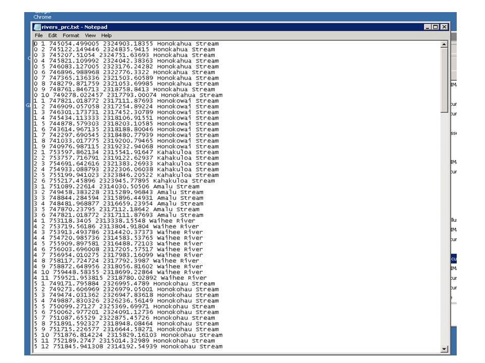

The screen Shots above were created for my GIS Programming course.  For this module we were to write two scripts, in the first script we were to create a ".txt" file and then write to it coordinates and Object IDs for vertices in a shapefile. In the second script we created a raster output that identified areas that fell within certain parameters, in this case, slope between 5 and 20 degrees and aspect between 150 and 270 degrees. Once this was completed the output was saved.

Friday, July 5, 2013

Module 6 Explore/Manipulate Spatial Data

The above screen shot is the results of the script I wrote for module 6 of my GIS Programming course. In this script we created a geodatabase and populated it with several shape files. We then created a dictionary and populated the dictionary with names and populations of county seats from an existing "cities" shape file.  Oddly enough I found the hardest part was not getting the script to work but getting it to print the above messages!

Sunday, June 30, 2013

Module 5 Geoprocessing with Python

This is a screen shot of the script I created using Python for my GIS Programming course.  Most of the script went well, with the exception of the Adding XY data. We had to utilize the "Desktop Help" menu for this. Having absolutely no experience in Python this proved to be a challenge.  We were given some direction so I eventually figured it out. 

Friday, June 21, 2013

Module 4 Dice Game Script

This is a screen shot of the results of a script from my GIS Programming course.  We were given a script with 8 errors and had to find and fix them so the script would run.  This was by far the most challenging module in Programming to date! Not to mention I had to run it about 30 times before Phillip finally won! Just Saying!!

Sunday, June 2, 2013

GISProgramming Module 3 Script


This screen shot is the result of a python script that I wrote for my GIS Programming course. We are currently in the third week. In this module we were to create a script that would identify the number of letters in our last name, and multiply that number by 3, and finally print our last name and that number. In my case as you can see it was “Carter 18”

Thursday, May 30, 2013

GIS Programming Soil Erase Shape file

 
This is a screen shot of a shape file I produced in my GIS Programming course. We were given two shape files (soils, basin)and instructions to create a model that would select all "Not prime farmlands" from the soils shape file, then erase those areas from the basin shape file.  The result is the above shape file, which I named soils_erase. Having no experience in model building or script writing I was not looking forward to this class, and although it has just started, I feel a little more confident about surviving this course.

Sunday, May 19, 2013

GIS Programming Screen Shot

This is a screen shot of my "S" drive.  These folders were all created by running a Python script provided by the GIS Programming course I am currently enrolled in. This is the first assignment for the course, I have no background in programming or scripting and I am hoping to keep my head above water and learn as much as possible.